- Get link
- X
- Other Apps
- Get link
- X
- Other Apps
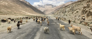
The Pamir Highway is part of the M41 trunk road , which is the "so called" second highest passable mountain road in the world after the nearby Karakoram Highway. It connects the entire Pamir region from Dushanbe, the capital of Tajikistan, to Osh in Kyrgyzstan. Many travellers on the silkroad did called it as one of the most beautiful parts of their jorney.
As far as up in the mountains, at over 4,000 meters, nature is relentless and merciless. "So called, because there are many andean passes in south america which hits the same height, like showed here.
To travel the Pamir Highway, you need both a valid visa for Tajikistan and a special permit for the Pamir Highway, the so-called GBAO Permit. Both entry documents are checked at regular intervals at military border posts along the entire Pamir Highway and are easily available online.
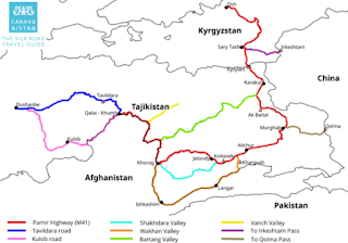
Like the Maps above shows are there several route options to choose. We suggest that you plan enough time to be able to drive severall legs of that beautoful region!
Mostly we selfdrivers are travelling there, but you can also take a flight and rent a car (which mostly seems to comes with a driver). 10 Day Jeep Group tours will cost around 400$, calculated with 4 travellers.
Use the iOverlander app, which really contains all the important information for overlanders and self-propelled drivers (accommodation, restaurants, attractions ...). iOverlander is on our list of the most important travelling apps.
The Border to Kyrgyzstan is easy to cross, there is no visa is required to enter Kyrgyzstan.
Above is a map of carvanistan which I did find at https://qvartzbulance.wordpress.com which shows even more details of the route options and visualize the surrounding countrys a bit better.
Here below you can find POIs and Waypoints for Fuelstations, Hostels and more, found as Hubb who is a very very helpful travelling community.


Comments
Post a Comment