- Get link
- X
- Other Apps
- Get link
- X
- Other Apps
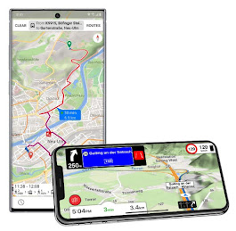
Shortly before our vacation I discovered the «Magic Earth» app. Many may now think - "not another navigation app". But what is offered is really more than just exciting. Especially for us overlanders. Because the app combines what was previously necessary for several different apps. Here are the most important functionalities:
satellite view
Satellite view with elevation profile
Open Street Maps
good routing with elevation profile
Offline capable (download per country)
Online traffic management with traffic jam bypass
Apple Carplay capable
Integration with Apple Watch
Hiking/biking - off-road navigation
Import / maintain POI with backup
In the meantime I've covered several thousand kilometers with Magic Earth - and I'm thrilled. Especially the 3D functionality is helpful when choosing a route and looking for a parking space, especially in regions with mountains and hills, the orientation with the 3D view helps enormously.
Offline travel navigation with 3D maps, online traffic guidance, elevation profile, off-road navigation and a good POI database. A little review!
Overlanding tours in the Andes, the western Alps, the Pyrenees or mountain pass tours in the Alps are much easier and easier to plan.
With "What's nearby" and "Search in the area" you can get information at any point on the map. Of course you can also create your own POIs, maintain them and save them in the cloud. At any point on the map you can also access other online services, weather report, sunrise, sunset, time zone. Any waypoints can be set, shared (social media, messenger, email - or just copy the coordinates to the clipboard.
When navigating as a pedestrian, local public transport with offers, including shipping, ferries, etc.
The app has more than just potential - it will replace at least four apps on my smartphone, which we have already reported on here. Corresponding replacement candidates are:
Here (offline navigation with street name and house number)
Mapout (3D map view)
Maps.me Openstreetmaps //& POI
MotionX (satellite view)
Google Maps (traffic jam bypass, road navigation)
I'm curious how you find the app - and whether the app will also lead to the replacement of various other apps for you. The app can also be used together with the smartphone as a dash cam & crash recorder - and offers various assistance systems. I haven't been able to test this myself yet - maybe an active reader will find a little more time here!
Magic Earth is free, you can find it in your app store for Android and iOS! This Article is also available in other languages.


Comments
Post a Comment